Reading the Ocean Like a Map: The Stick Chart Navigation of Micronesia
Reading the Ocean Like a Map: The Stick Chart Navigation of Micronesia
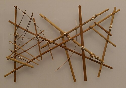
In the collections of natural history museums from London to Honolulu, there are objects that curators typically display with a note of wonder and a degree of admitted incomprehension: lattices of palm midrib and pandanus root, roughly thirty centimeters square, with small cowrie or cone shells lashed at irregular intervals to the crossing points of the sticks. The labels call them "stick charts" and identify them as navigational instruments of the Marshall Islands. Most visitors look at them for a moment — intriguing, clearly skilled, impossible to read — and move on.
They are moving on from one of the most sophisticated knowledge systems ever developed by human beings in response to a specific environmental challenge. The stick charts of the Marshall Islands encode a model of ocean behavior — the patterns of swell, current, and wave refraction across thousands of square kilometers of Pacific Ocean — that allowed Micronesian navigators to make open-water voyages of hundreds of miles with a reliability that European sailors of the same period, equipped with compasses, sextants, and printed charts, could not match. The stick chart was not a primitive predecessor to the nautical chart. It was a different technology, operating on different principles, solving a different version of the navigation problem — and in several respects, solving it better.
Understanding what the stick charts actually represent requires setting aside the assumption that a navigational tool must look like what we expect a map to look like. It requires, instead, entering a mode of environmental perception for which most people raised in land-based, visually-dominant cultures have no ready framework. The ocean, to a Marshallese navigator, was not an empty obstacle between islands. It was a structured medium — full of readable information, organized into patterns that a trained perception could interpret as reliably as a literate person reads text.
The Ocean as Information Environment
The Pacific Ocean is not homogeneous. Across its surface and through its depths, multiple systems of movement interact in ways that create locally distinctive patterns: the long, rolling swells generated by distant storms travel for thousands of kilometers before reaching island chains, where they encounter the shallow water and land masses that reflect, refract, and diffract them into secondary wave patterns. The interaction of the primary oceanic swell with island-generated interference produces wave signatures that are, to a trained observer, as specific to a location as a fingerprint.
Marshallese navigators identified and named the major swell systems of their ocean. The **Kaelib** swell runs from the northeast, generated by the trade wind systems of the North Pacific. The **Rilep** runs from the north, associated with seasonal storm systems. The **Bungdockerik** comes from the southeast. Each swell system has a characteristic period (the time between wave crests), amplitude, and direction of propagation — and each interacts with the Marshall Islands' two parallel chains of atolls (the Ratak, or Sunrise, chain in the east, and the Ralik, or Sunset, chain in the west) in ways that create predictable, learnable patterns of wave deformation.
At the approaches to an island — sometimes thirty, forty, or even a hundred kilometers away from land, well beyond any visual horizon — the sea surface carries information about what lies ahead. The swell, encountering the shallow atoll platform, begins to slow and bend toward it. A navigator who knows what to feel for — lying in the hull of the canoe, sensing the vessel's motion through the body rather than watching the water — can detect the altered swell pattern that signals the presence of land before any visual cue is available. The island announces itself through the water.
This is the knowledge the stick charts encode. They are not maps of geographic position in the conventional sense — they do not show where islands are in relation to each other in terms of distance and compass bearing. They are models of ocean behavior: the arcs of palm midrib represent swell patterns, their curvature showing how the swells bend around and between island groups. The shells represent islands. The crossing points of sticks represent where swell systems interact, creating the specific wave signatures that navigators used to determine position and direction of travel.
Three Charts for Three Purposes
Marshallese stick chart tradition produced at least three distinct types of charts, each serving a different function in the transmission and application of navigational knowledge.
The **mattang** is a teaching chart — a schematic representation of general wave behavior principles rather than a specific geographic area. It typically shows the interaction of swell patterns around a single island or small group, demonstrating the basic principles of wave refraction and diffraction that govern all the more complex patterns a navigator would need to know. The mattang is the pedagogical foundation: before a student can read the specific wave signatures of the Ratak chain, they must understand the underlying physics of how waves behave around land, and the mattang provides that understanding in a manipulable, discussable physical form.
The **rebbelib** is a comprehensive chart of either the Ratak or Ralik chain — a larger, more complex structure encoding the wave patterns, swell interactions, and navigational landmarks across an entire island chain. The rebbelib is specific enough to be practically useful for planning a voyage between particular islands, and it is sufficiently complex that constructing and interpreting one represents a significant achievement of navigational knowledge. Not every navigator could make a rebbelib; its construction was the province of the most experienced and highly trained practitioners.

The **medo** is the most specific type: a chart of a particular inter-island route, showing the wave conditions a navigator would encounter on a specific passage. Where the rebbelib provides a general picture of an island chain's wave environment, the medo is route-specific — a detailed model of what a navigator would experience on the water between two particular destinations.
Critically, none of these charts were used at sea. This is the fact that most confounds visitors encountering stick charts in museum cases: these are navigational tools that were never taken on the voyage. They were used onshore for teaching, for memorization, for discussion between navigators — a physical vocabulary for talking about ocean conditions that would be encountered and read entirely through bodily sensation rather than visual reference during the actual passage. A navigator memorized the chart's information before departure and then navigated by feel, reading the ocean directly rather than consulting a representation of it.
The Body as Instrument
The centrality of bodily sensation to Marshallese navigation is the aspect of the tradition that Western observers have found most difficult to fully credit, and it is the aspect that most directly challenges the assumptions that Western navigational culture brings to the question of how spatial information can be known and used.
Marshallese navigators detected swell direction and pattern primarily through the motions of the canoe hull — the specific pitching, rolling, and yawing signatures that different swell systems produced in the vessel — perceived through a body lying or sitting low in the hull, attention directed inward to sensation rather than outward to visual horizon scanning. This is not a crude or imprecise mode of perception. The human vestibular system and proprioceptive apparatus are capable of detecting wave period and direction with considerable accuracy when trained specifically to do so, and experienced navigators could distinguish between swell systems that differed in period by a second or two and in direction by as little as ten degrees.
The training required to develop this perceptual capacity was both long and deliberate. Young navigators began learning ocean awareness from childhood — being placed in canoes in conditions of increasing complexity, directed to pay attention to specific aspects of the vessel's motion, taught the names of the swell systems and the characteristic feel of each. This was not passive observation; it was an education in a specific form of attention, a cultivation of sensitivity to a set of environmental signals that untrained observers simply do not perceive, not because the signals are absent but because the perceptual apparatus for reading them has not been developed.
The Marshallese term for the practice of reading wave patterns through bodily sensation is sometimes translated as "wave piloting" — though the English phrase fails to capture the full register of the Marshallese concept, which is less about piloting in the mechanical sense than about a form of attunement between navigator and ocean that experienced practitioners describe in terms that suggest intimacy as much as technique. The ocean is not a problem to be solved by the navigator. It is a medium to be listened to — and listening, in this context, is a full-body activity.
Etak: Navigating a World That Moves Around You
Closely related to the wave-navigation tradition of the Marshalls, and extending across the broader Micronesian and Carolinian navigational world, is a conceptual framework for understanding movement at sea that is so different from Western navigational assumptions that it initially appears simply wrong — until its internal logic becomes clear, at which point it reveals itself as a more perceptually accurate model than the one Western navigation typically employs.
The concept is called **etak** in the Carolinian tradition, and it inverts the conventional navigational figure-ground relationship. In Western navigation, the vessel moves through a fixed ocean. The ship travels from point A to point B; the water stays still. In etak, the vessel is conceptually stationary. The ocean and the islands move around it. When sailing from Saipan to Guam, a Carolinian navigator does not conceive of traveling toward Guam. Guam moves toward the canoe. The reference islands — islands that the navigator uses as positional landmarks along the route, typically islands off to one side of the course that are not the destination — appear to pass beneath the fixed star point that anchors the navigator's celestial reference, moving from ahead to beside to behind as the voyage progresses.
This inversion is not philosophical eccentricity. It is a perceptually accurate description of what the navigator actually experiences and observes: the vessel's position relative to the stars above is what remains most constant from moment to moment; the relationship of islands and reference points to both star positions and canoe heading changes continuously. Organizing the navigational model around what is actually most stable in the navigator's perceptual experience — the star paths overhead — rather than around an abstract fixed-coordinate geography produces a system that is easier to use in real-time navigation conditions precisely because it matches what the senses report.
The etak framework also integrates naturally with the star-path navigation system that underlies all Micronesian open-water wayfinding: the knowledge of which stars rise and set over specific islands, the sequence of star paths that corresponds to a specific route, the correlation between star position and wave direction that allows the navigator to maintain course when clouds obscure the sky by reading the swell instead.
Star Paths and the Living Sky Atlas
Every experienced Micronesian navigator carries an internalized atlas of the night sky organized not by constellation or celestial coordinate but by the island-specific rising and setting positions of named stars. The **star compass** — a mental model in which the horizon is divided into named positions corresponding to star rise and set points, and in which each named position corresponds to a specific bearing — is the primary directional tool of open-water Pacific navigation, and it is held entirely in the navigator's memory.
In the Carolinian tradition, the star compass is called **sidereal compass** by Western scholars and contains approximately thirty-two named positions, each associated with a specific star or star group and its corresponding bearing. The star Altair (*Mailap* in Carolinian) rises almost due east and sets almost due west, providing a reliable east-west reference. Polaris (*Fochur*), visible from Micronesian latitudes as a low-horizon star, marks north. The Pleiades (*Maan*), rising in the east-northeast, mark a specific bearing used in particular inter-island routes. The Southern Cross and its associated stars provide southern hemisphere reference points for voyages toward lower latitudes.
The integration of the star compass with wave navigation provides redundancy that makes the system robust against the conditions that would disable either method alone. When skies are clear, stars provide the primary directional reference. When clouds obscure the stars, the swell — whose direction changes slowly enough that several hours of cloud cover does not cause the navigator to lose orientation — provides the directional baseline. When both swell and stars are obscured by storm conditions, the navigator uses current, the behavior of seabirds, and the color and temperature of the water to maintain approximate orientation until conditions improve.
This redundancy is designed, not accidental. The navigational system was developed over millennia in conditions where any single-channel navigation method would fail with regularity, and its multiple overlapping channels represent the accumulated problem-solving of countless voyages — both successful and catastrophic — across one of the most challenging ocean environments on earth.
Who Held the Knowledge: Navigators, Lineages, and Secrecy
Navigation in Marshallese and Carolinian society was not general knowledge. It was a hereditary specialization, held within specific lineages and transmitted through apprenticeship relationships that combined technical instruction with social and spiritual preparation. The navigator (*ri-meto* in Marshallese, *pwo* in Carolinian) occupied a specific social position — respected, essential, and in some traditions understood to possess access to forms of perception and protection that went beyond ordinary human capacity.
The initiation of a fully qualified navigator in the Carolinian tradition — the *pwo* ceremony — involved community celebration, the formal recognition of the initiate's readiness by established navigators, and what participants describe as a transformation in the initiate's relationship to the ocean: not merely the acquisition of a skill set but the assumption of a social and spiritual identity as someone who mediates between the human community and the ocean world. The ceremony was last widely practiced in the mid-twentieth century and has been revived in modified form in more recent years as part of the broader Pacific wayfinding renaissance.
The secrecy surrounding navigational knowledge was both protective and generative. Protective because the knowledge was the navigator's lineage's economic and social asset — sharing it indiscriminately would dilute its value and the lineage's status. Generative because the framework of restricted knowledge created a structure of aspiration: the apprentice who could demonstrate sufficient dedication, perceptual capacity, and good judgment over years of training would be progressively admitted to deeper levels of the knowledge system, the revelation of each layer representing both technical advancement and social recognition.
This structure also meant that navigational knowledge was not uniformly distributed even among practitioners. The most experienced navigators knew routes and wave signatures that younger practitioners did not, and the deepest knowledge — the understanding of rare conditions, difficult passages, and the full complexity of the swell interaction patterns around the most navigated inter-island routes — was held by very few individuals at any given time. The social consequence of this concentration was the community's dependence on specific individuals for access to the most distant islands, which in turn gave those individuals significant social and political influence.
Contact, Disruption, and the Near-Loss of Everything
European contact with Micronesian societies beginning in the sixteenth century introduced disruptions to the navigational tradition that accumulated slowly at first and then catastrophically in the nineteenth and twentieth centuries. The most immediately damaging was not any specific suppression of the tradition but the introduction of trade goods and economic relationships that reduced the practical necessity of inter-island voyaging under sail. As motorized transport and colonial trade networks made European-style boats and scheduled shipping connections available, the long-distance canoe voyages that had maintained and tested navigational knowledge became rarer. Knowledge that is not exercised degrades; navigational traditions that are not employed in real voyages lose the practical feedback that keeps them accurate and alive.
German, Japanese, and then American colonial administration of Micronesia across the late nineteenth and twentieth centuries variously discouraged traditional voyaging through explicit policy and through the restructuring of island economies in ways that made the traditional inter-island exchange networks — the economic foundation of long-distance navigation — less viable. By the mid-twentieth century, there were parts of Micronesia where the lineages that had held navigational knowledge for generations could no longer point to active practitioners capable of making the traditional long-distance voyages.
The stick charts themselves entered a complicated relationship with the collector and tourist market. By the early twentieth century, Marshallese craftspeople were producing stick charts for sale to European and American visitors and colonial administrators — a commercial production that maintained the craft's material form while evacuating much of its functional content. The charts being sold were often stylistically derived from genuine navigational charts but not encoded with accurate wave information; they were souvenirs of a knowledge system rather than specimens of it. The museum collections that house stick charts today include both genuine navigational instruments and commercially produced decorative objects, and distinguishing between them requires specialist knowledge that was not always applied when collections were assembled.
The Renaissance: Hokule'a, Mau Piailug, and the Recovery of Wayfinding
The most consequential event in the modern history of Pacific traditional navigation was the construction and first voyage of the Hokule'a — a Hawaiian double-hulled voyaging canoe built to traditional specifications and sailed from Hawaii to Tahiti in 1976 using traditional wayfinding methods alone, no instruments. The navigator for that voyage was Mau Piailug, a master navigator (palu) from the Carolinian island of Satawal who was among the last living practitioners of the complete traditional navigation system.
Mau's decision to share his knowledge with Hawaiian navigators — a decision that crossed cultural and geographic boundaries that traditional knowledge-sharing protocols would not normally have permitted — was motivated by his awareness that the knowledge was dying within its home communities and that documentation and transmission, even to non-Carolinian students, was preferable to disappearance. The Hokule'a's successful voyage — 2,500 miles of open Pacific Ocean navigated by star, swell, and current without instruments — demonstrated to both the Pacific and the Western scientific community that traditional navigation was not approximate or lucky but a precise and reliable system capable of performing exactly what its practitioners had always claimed for it.
The voyage catalyzed a Pacific-wide wayfinding renaissance. The Polynesian Voyaging Society in Hawaii expanded its programs, training new generations of navigators under Mau and his students. In Micronesia, the Mau Piailug Foundation and the traditional navigation school on Satawal have continued transmission of the Carolinian knowledge system. In the Marshall Islands, efforts to document and revitalize the stick chart tradition have proceeded alongside the broader wayfinding revival, with researchers working with remaining knowledgeable elders to reconstruct the full interpretive framework of the charts before it is lost.
Mau Piailug died in 2010, having trained dozens of navigators across Polynesia and Micronesia and having demonstrated, in a career of extraordinary generosity, that traditional knowledge can survive the apparent conditions of its disappearance if someone decides, with sufficient commitment, that it will.
What the Sticks Actually Say
The stick chart sitting in a museum case in London is, in isolation, approximately as useful as a book in a language you cannot read. Its information is real and encoded with precision, but accessing it requires a framework of knowledge — of which swell systems operate in the Marshall Islands, of how wave refraction works around atoll platforms, of the correlation between specific stick configurations and specific ocean conditions — that the chart itself cannot provide. The chart is a mnemonic and a teaching tool, not a self-explanatory document. It assumes a reader who already knows most of what it contains.
This is a feature, not a limitation. The stick chart's dependence on an informed reader is the characteristic of a knowledge system designed for transmission between practitioners, not for broadcasting to strangers. It works within a community of knowledge, and its opacity to outsiders is the opacity of any specialized technical language: impenetrable from outside, precise and efficient from within.
What the sticks say, to someone who knows how to read them, is this: the ocean is not empty. It is structured, patterned, readable — a medium full of information for the navigator trained to perceive it. The arcs of palm midrib say: here is how the swell bends around land. The shells say: here is where the islands are, fixed in the wave field that surrounds them. The crossing points of sticks say: here is where swell systems interact, where the sea surface is most complex, where attention must be most acute.
And underneath all of this, implicit in every fiber of pandanus root and every lashed cowrie shell, is the larger claim that the knowledge system makes: that the Pacific Ocean, which Western cartography rendered as emptiness punctuated by small islands — a vast blue absence between places of interest — is, to the people whose civilization it enabled, not empty at all. It is home. It is structured. It is readable, navigable, intimately known. The ocean does not separate the Marshall Islands from the Carolines. It connects them — and the sticks and shells that model its behavior are the physical form of the knowledge that made that connection possible, for a thousand years of voyaging, before anyone thought to write it down.